WaterWidgets

The WaterWidgets project is a collection of Dashboard Widgets focused on the wet world around us.

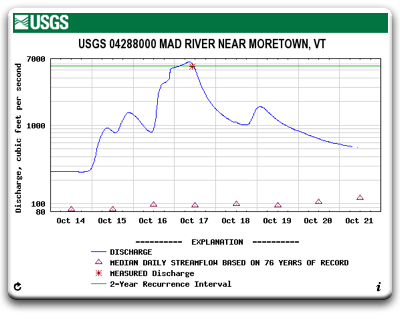
A shining example of our tax money put to good use, the U.S. Department of the Interior's United States Geological Survey (USGS) is a wonderful resource. Founded in 1879, today the USGS measures and monitors [via satalite uplink] the amount of water flowing through our rivers, streams, and canals at thousands of sites around the country and provides this data to us on their website. While in no way [except for common citizenship] affiliated with the USGS, this project aims to make their wonderful data more readily accessible.

RiverLevels

Download: RiverLevels.wdgt

The RiverLevels widget provides an easy way to monitor the amount of water flowing in your favorite streams and rivers right from your Dashboard. The RiverLevels widget is of particular interest to whitewater kayakers and canoeists.

Once any United States Geological Survey (USGS) stream-gauge station is selected, it is automatically refreshed to always provide you with the latest graph of the water-level.

Mac OS X 10.4 Tiger is required. If you're using Safari, click the download link. When the widget download is complete, show Dashboard, click the Plus sign to display the Widget Bar and click the widget's icon in the Widget Bar to open it. If you're using a browser other than Safari, click the download link. When the widget download is complete, unarchive it and place it in /Library/Widgets/ in your home folder. show Dashboard, click the Plus sign to display the Widget Bar and click the widget's icon in the Widget Bar to open it.

About

WaterWidgets is currently developed and maintained by Adam Franco.

Feedback and Help